Our Services

Mapping and GIS

Mapping and GIS Services for Clearer Planning, Better Coverage, and Smarter Land Management

Turn Property Data Into a Clear Plan You Can Actually Use

Mapping and GIS Services for Planning, Documentation, and Smarter Land Decisions.

As land and vegetation projects grow in size, it becomes harder to track what has been treated, what still needs attention, and where risk areas are building. Mapping and GIS help clarify the process by turning property information into visual plans you can understand and use. From identifying treatment zones to documenting work completed over time, accurate mapping supports better decisions and better results.

ForestScapes LLC provides mapping and GIS services to support forestry, fuels reduction, defensible space, and long-term land management projects. We help define boundaries, organize treatment areas, and create documentation that keeps your project on track. Whether you are managing a larger parcel, coordinating work across multiple areas, or want clearer planning before crews begin, mapping tools provide structure, accountability, and a smoother path forward.

When Mapping and GIS Make the Biggest Difference

Mapping is most valuable when you need clarity and consistency across a property or project. Whether your work is ongoing or spread across multiple zones, GIS helps you plan smarter, track progress, and make better decisions over time.
Check

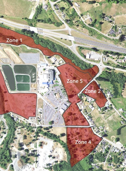
Define Treatment Areas Clearly

Property lines, zones, and priorities are easier to manage when they are mapped. Clear boundaries reduce confusion and overlap.

Check

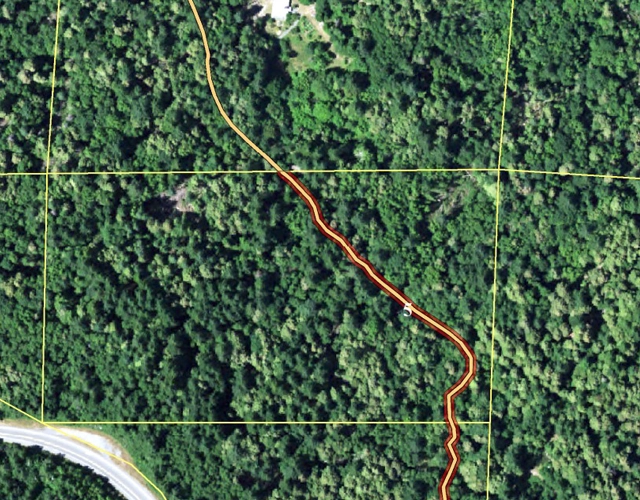
Improve Project Planning and Coverage

Mapping helps you plan routes, access points, and treatment sequencing. It supports more efficient work and better outcomes.

Check

Track Work Completed Over Time

Documentation shows what has been treated and when. This helps guide maintenance schedules and future planning.

Check

Identify High-Risk or High-Priority Zones

GIS can highlight fuel buildup, access challenges, and areas of structural exposure. It helps focus effort where it matters most.

Check

Support Reporting and Communication Needs

Clear maps make it easier to share project details with partners, agencies, or property stakeholders when needed.

A Practical Mapping and GIS Process Built for Real-World Projects

We use mapping tools to support clearer planning, better organization, and easier long-term tracking. The goal is simple: turn property information into a plan that helps work stay consistent and measurable.
Check

Site Review and Project Goal Alignment

We confirm the scope, objectives, and key areas of focus to ensure the map supports the property's real needs.

Check

Boundary and Zone Mapping

We define treatment zones, access routes, and priority areas to create a structured plan for work sequencing.

Check

Data Organization and Documentation

We capture and organize project information so progress can be tracked clearly from one phase to the next.

Check

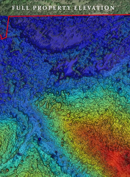
Visual Planning and Decision Support

Maps help guide treatments, highlight gaps, and support smarter decisions as conditions change over time.

Check

Final Deliverables and Next-Step Guidance

You receive clear outputs that support execution, maintenance planning, and future land management priorities. .

Mapping and GIS Support That Keeps Projects Organized From Start to Finish

When a property includes multiple treatment zones, changing terrain, or long-term vegetation goals, it is easy for work to become inconsistent over time. Mapping helps solve that by creating a clear visual plan of what matters most, where work should happen, and how progress can be tracked. Instead of relying on memory or scattered notes, you have a structured way to plan treatments and confirm coverage.

ForestScapes LLC uses mapping and GIS to support fuels reduction, defensible space planning, and broader forestry projects that benefit from organization and documentation. We help define boundaries, identify priorities, and deliver practical solutions that support field work. The result is better coordination, fewer missed areas, and a clearer path for ongoing maintenance, especially when projects extend across seasons or multiple phases.

ForestScapes LLC: Mapping and GIS Services for Clearer Planning and Better Long-Term Results

If you want land management work to stay organized, consistent, and easier to maintain, mapping and GIS can make a measurable difference. ForestScapes LLC provides mapping and GIS services across Northern California to support fuels reduction, defensible space planning, forestry projects, and ongoing vegetation management with clear documentation and structured planning.

Our team will align the mapping process with your goals, define treatment zones and boundaries, and create visual tools to guide on-the-ground work. Whether you need better coverage planning, progress tracking across seasons, or documentation for communication and decision-making, we focus on practical outputs that support real-world action. With clearer planning and a reliable record of completed work, it becomes easier to prioritize next steps and keep the property moving in the right direction.

Schedule a free assessment at (707) 382-8702, and let’s bring clarity and structure to your next project plan.

WHy CHoose Us

Trusted planning, safe execution, and results you can see across every type of property.

Licensed and Insured

Safety-First Decisions

Every job starts with risk awareness, controlled work zones, and careful steps that protect people and structures.

High-Quality Service

Clear, Honest Recommendations

We explain what needs attention, what can wait, and why, so you can make confident choices.

Affordable Price

Full-Service Capability

From tree removal to defensible space and land clearing, you get one team that can handle it all.

Quick and Fast response

Professional Site Cleanup

We haul debris, manage slash responsibly, and leave your property clean, usable, and easy to enjoy again.

24/7 Emergency Tree Service

Wildfire Mitigation Focus

We build defensible space and reduce fuels with practical strategies suited to Northern California conditions.

Discount Available

Respect for Your Property

We protect surrounding trees, surfaces, and landscaping, and work carefully around driveways, fences, and utilities.

Friendly Customer Service

Reliable Communication

You will know the plan, timeline, and next steps, with updates that keep the project moving smoothly.

Get Your Free Assessment

Built for Complex Jobs

Large hazardous trees, difficult access, and technical projects are handled with the right equipment and planning.

40+ Years of Certified Excellence in Tree Care, Restoration, and Fire Prevention

Call Us for More Information
Call Now Button